Street View Page on
France
Google
Street View is available through Google Maps and Google Earth and provides
panoramic views along many streets in the world. It was started in 2007 in the
United States and has since expanded to include a large number of countries.
Some countries have objected to this form of data gathering and have not
allowed Google to take the imagery, Germany being the main hold-out. Available
Street View imagery available is shown as blue lines on Google Maps once the
so-called pegman has been activated. Images are most
often taken by car but a variety of other modes of transport have been used.
Once captured, the images are subsequently stitched together. In some areas,
Street View images are augmented by privately-done photospheres.
Outline
- Street View screen captures
- First StreetView of Eiffel Tower in France...
- Second StreetView of Le Puy-en-Velay
- Third StreetView of Mont Saint-Michel
- Links to Street View panoramas
- Link to first panorama
- Link to second panorama
- Link to third panorma
- TripGeo Street View Animations
- Route from x to y
- Route from y to z
- Route from z to x
- Moore's Where to Invade Next
- The value of travel
1 Street View
Screen Captures
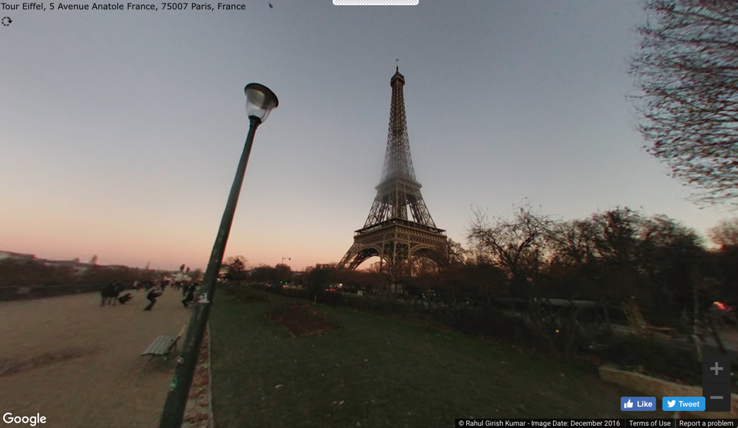
The Eiffel
Tower is a very destined tourist attraction and the symbol of France. It was opened in 1889 after celebrating
the centennial of the French Revolution.
Over 250 million people have visited it.
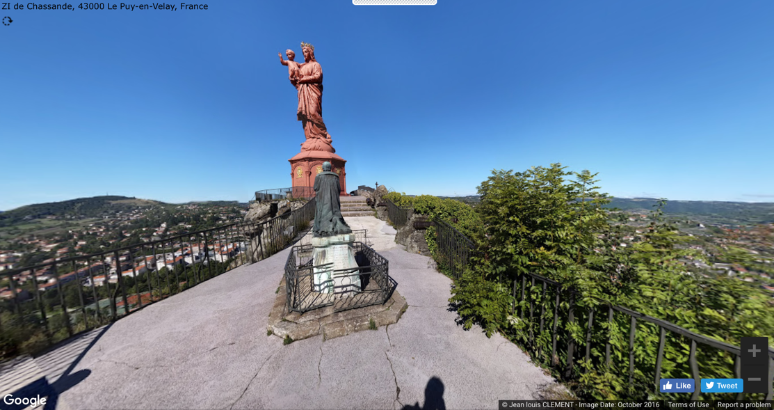
Le Puy-en-Velay statue is a shrine to the Virgin Mary. It sits by the cathedral, and it started
its construction in as early as the 5th century. There are records of it being built all
the way until the 15th century based on its architecture.
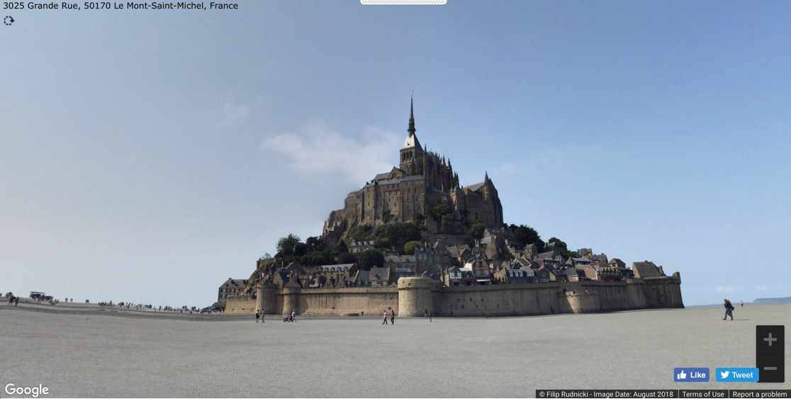
Mont
Saint-Michel is a small island located in France just off the coast of
Normandy. It was a very
popular destination for pilgrims in the Middle Ages. The island is connected to the mainland
by one road with bridges.
2 Links to Street
View Panoramas
Insert three links with descriptions to Street View Panoramas here.
Example-1: https://mapstreetview.com/#t37cy_1d6fl_4r.0_lf86
Example-2: https://mapstreetview.com/#qtf80_2b83c_5q.1_-4a10
Example-3: https://mapstreetview.com/#syey5_-wbhm_8n.e_ec13
(Links were created by going to the location and clicking on the Pegman (yellow man in corner of Google Maps). Drag the Pegman over the map and choose a location on a blue line that has a good point to view of the feature. Once the Street View image is visible, copy the web address. In Word, write out the name of the feature (e.g., Eiffel Tower in Paris), highlighting the text, and then choose Insert Hyperlink and paste the address.)
3 TripGeo Streetview Player
The TripGeo Streetview Player tool stitches Google's panoramic street view data into an animation. In the dialog, you can enter the start and end location of your trip. When you click Preview, the route is marked on a map and the StreetView images will start playing. You can control the method of travel, the pace of the timelapse, and the distance between StreetView images.
(This graphic was created by taking a screenshot. You'll need to click on "Create Your Directions Map" before this graphic appears.)
StreetView animation near Edinburgh, Scotland.
(This link was created by clicking on View Directions and Map, and then on View Map. This gets you to a page that displays the Street View and the map. Simply copy the address of the page. In Word, enter the text for the link, highlight, and choose "Insert Hyperlink". Paste the address. The address can also be attached to the image – as above – using the same Insert Hyperlink command.)
This Street View animation takes us between two locations in Scotland. At the beginning, one sees an older residential area. We then drive through the lush, green countryside into a new residential area.
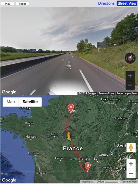
Route from the Eiffel Tower to Le Puy-en-Velay
Link to animation StreetView animation Eiffel Tower to Le Puy-en-Velay
Desription It’s quite a long road trip, approximately 5½ hours and 543km. It’s mostly highway driving through the countryside of France. This route travels through the cities of Versailles, Orleans and Bourges.
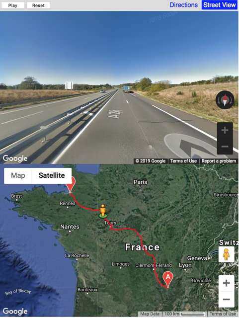
Route from Le Puy-en-Velay to Mont Saint-Michel
Link to animation StreetView animation Le Puy-en-Velay to Mont Saint-Michel
Desription Another long road trip. This one is longer being around 7½ hours and 726km. Once again it’s mostly driving on the highway and this route goes through the cities of Le Mans, Tours and Bourges.
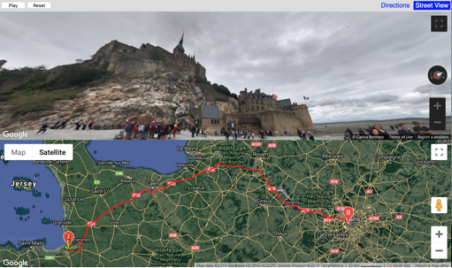
Route from Mont Saint-Michel to the Eiffel Tower
Link to animation StreetView animation Mont Saint-Michel to Eiffel Tower
Description Yet another long road trip. This one allows goes through two of France’s national wild parks. This route is the shortest of the three being just under 4 hours and 356km.
4 Moore's Where
to Invade Next
Moore's documentary is politically polarizing. Conservative columnists, such as Armon White, are sharply critical of the movie. First, comment on the validity of White's negative review. Then, putting aside politics, what can the movie show us about the value of travel in understanding our own country.
There are many points showing that White doesn’t like this film as well as not liking Moore. There really isn’t a review of the movie where it’s more of what he doesn’t like about Moore. The movie does show some differences on certain things between the US and the other countries. For example; the gun control, prisons and crime in general. Without the politics it would show how the US and other countries differ from an unbiased side. The US doesn’t have ideal laws and ways we run certain things so by looking at other countries we could change to better enhance our country.
Submitted
by Zach Coartney on 4-5.